Flandrien in your pocket: Westtoer engages cycling fans
Business context
Westtoer was looking for a way to strengthen the promotion of cycling events in Belgium by focusing on modern, mobile experiences for tourists and local enthusiasts. In 2015, applications combining imagery, augmented reality and social media were rapidly gaining importance, creating an opportunity to build reach through user-generated content.
In response, the concept of Flandrien Cam was created — an app that overlays cycling-themed elements on photos, supports route and map point discovery, and strengthens the marketing of regional events. GPS and maps (Google Maps and Open Maps) were used, providing both online and offline modes so users could use the app in the field, regardless of connectivity.
Challenge
The key challenge was to design an engaging tool that would allow fans to “become a Flandrien” — a resilient cyclist ready for any weather — through creative photo overlays and easy social media sharing. The solution was intended to generate a viral effect, increasing event recognition and fans’ identification with the races.
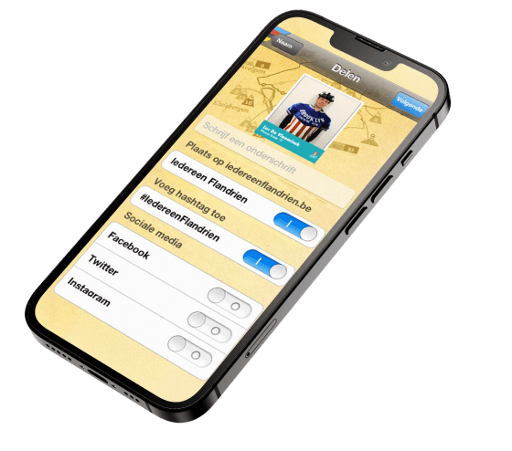
From a technical perspective, it was necessary to seamlessly combine the camera and AR filters with easy sharing to Facebook, Twitter, Flickr and Instagram. In addition, the app had to handle GPS and maps (Google Maps, Open Maps) with precision, work without constant internet access, and reliably synchronise data once connectivity was restored — which is critical during outdoor activities.
Solution
The Leaware team delivered Flandrien Cam, streamlining its own development process and placing strong emphasis on interface simplicity as well as the speed of the camera and filters. The project was run iteratively to test hypotheses around engagement and sharing across social channels as quickly as possible.
The app implemented a set of filters and overlays that turn the user into a Flandrien in just a few steps, together with a one-tap publishing feature for Facebook, Twitter, Flickr and Instagram. GPS integration with Google Maps and Open Maps enables route planning and discovering points on the map, while local storage and offline mode ensure access to data in the field. Mechanisms were prepared for integration with external systems as well as secure synchronisation once the connection was restored.
The result is not only a marketing tool that builds buzz around the races, but also a new communication channel with fans. The app supports education about the history of cycling, provides event information, and strengthens users’ emotional engagement.
Key metrics
over 2000
Downloads after 12 months
2000+ new installations during the first year after launch